Animal behavior has fascinated everyone from young children to scientists for centuries. Humanity’s interest expanded when we discovered the incredible distances that animals will travel. This explains why no student has ever completed their education without a lesson on the migratory patterns of various animals, and thus why, “birds fly south for the winter” is now household knowledge.
We know that animal migration is as much a part of Earth’s evolutionary history as the rocks on it, so you might be wondering - what has us so interested now? We’re glad you asked.
Understanding how and why animals move through and between resource-rich habitats can help us craft successful management plans to recover and maintain their populations. In the ocean, we seldom know these basic behaviors which are a requirement for their survival. In order to accomplish this, we must tag and track animals to reveal their behaviors, movement paths, and important life-history locations--like where they breed and feed--to better mitigate human impacts. Simply put, protecting them requires an understanding of where they go and what they do when they go to a particular place. This growth of the emerging discipline known as Movement Ecology is currently restricted due to lack of innovation in tracking systems. For decades, animal tracking has been accomplished with a variety of animal tracking tags that currently deliver telemetry data to the Argos satellite system.
Argos has two main functions, the first is to provide daily list of any type of tag that transmits to the satellite (on their specific frequencies), and relay that data back to us on Earth. The second function includes the first but adds a tracking function. For example, PTT 'beacon’ tags are tracked by using the ‘Doppler Shift’ effect of fast-moving satellites in relation to relatively static tags. This effect, combined with software analysis, determines the location and movement path of tagged animals in near real-time. Unfortunately, this system is constrained by the limited number of satellites, data bandwidth, transmission costs, and spatial coverage on Earth. Additionally, proprietary systems do not have an open standard for transmitting data, leading to limited receiving and tracking options.
The current system of tracking animals often leaves biologists with more questions than answers. This is especially true for marine mammals, sharks and sea turtles that may only occasionally surface--providing a narrow window of time to locate them and transmit invaluable data. In addition, the error rate on a location can be in excess of 1500 m depending on its latitude. Scientists are missing out on valuable data due to the spatial and temporal coverage, accuracy, and restricted data packet size of the current system. A solution to these challenges would drastically improve our ability to protect and conserve endangered and vulnerable species.
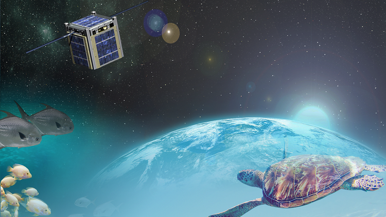
The Bureau of Ocean Energy Management (BOEM) has teamed with the National Aeronautics and Space Administration (NASA) to find a solution that private industry, academia, conservation scientists, and government agencies are deeming a necessity. BOEM is charged with the great responsibility of protecting the environment while ensuring the safe development of the US’s offshore energy and marine mineral resources. NASA is interested in investigating various opportunities for the potential use of small satellite (SmallSat) technology, such as CubeSats, for remote surface tracking capabilities on future lunar or other deep space destinations. It also aligns with NASA’s goal to support other Federal agencies’ work and to test, validate, and optimize innovations.
A CubeSat (U-class spacecraft) is a type of miniaturized satellite for space research that is made up of multiples of 10×10×10 cm cubic units. CubeSats have a mass of no more than 1.33 kilograms per unit, and often use commercial off-the-shelf (COTS) components for their electronics and structure. NASA and BOEM see great promise in the potential for SmallSat technology to play an integral role in the future of animal telemetry data collection and standards. When imagination meets reality, the potential for major advancement in movement ecology is unlimited.
This is where you come in.
This challenge is seeking ideas and concepts that incorporate SmallSat/CubeSat technology along with other space, stratosphere, land, and/or water surface systems to improve upon the current system of data reception for tracking animal position and path movement. This ideation challenge is the first in a possible series of challenges addressing Next Generation Animal Tracking. Submissions to this Challenge may be used as input to future challenges anticipated to focus on technical solutions for an open system architecture and software integration.
What You Can Do To Cause A Breakthrough
- Click ACCEPT CHALLENGE above to sign up for the challenge
- Read the Challenge Guidelines to learn about the requirements and rules
- Share this challenge on social media using the icons above. Show your friends, your family, or anyone you know who has a passion for discovery.
- Start a conversation in our Forum to join the conversation, ask questions or connect with other innovators.
Challenge Breakthrough
NASA and The Bureau of Ocean Energy Management (BOEM) are seeking your ideas for how to use emerging SmallSat/CubeSat technology along with other Space, Stratosphere, Land, and/or Water systems to improve the spatial and temporal coverage, spatial accuracy and/or data packet size of animal telemetry data collection and tracking.
Prize
A total prize pool of up to $30,000 is available. Up to 3 awards are planned with the minimum prize being no lower than $5,000.
Timeline
Open to submissions September 12, 2018
Submission deadline November 8, 2018 @ 5pm ET
Judging November 9 to December 17, 2018
Winners Announced December 18, 2018
What is the potential for improved animal telemetry data collection beyond Argos?
Current tracking technology provides limited coverage and is costly. Currently, six Argos satellites fly in a polar orbit 850 km above Earth collecting tag data in short intervals, storing the data and transmitting it down to a limited number of receiving stations for distribution to users.
Argos overview
Characteristic | Present |
Number of Satellites | 6 |
Orbit Type | Polar |
Footprint | 5000 km |
Observation Frequency | 14 times/day |
Observation Time | 10 min. avg. |
Planned Mission Duration | 3 years |
Communication System | 401.650 MHz +/- 30 KH |
Spatial and Temporal Coverage:
Due to the small number of satellites, the sensing observations are typically limited to one to two times per day, for two to four minutes, for each satellite for a given region. For instance, a tagged turtle must surface during the exact time that the satellite is overhead in order for it’s position to be received by Argos. Increasing the spatial and temporal coverage of an animal tracking system would greatly improve the amount of data that can be acquired.
Data Packet Size/Data Pipe:
New tagging technologies often require more bandwidth than Argos can currently support. These tags are currently non-transmitting and need to be manually retrieved at the end of their life. For instance, a tag on a whale shark can track the number of flipper movements per second as well as other biometric and environmental variables. This data is too large to be transmitted to Argos and so the researchers rely on seeing the animal again to retrieve the tag or recovering it once it is floating. This results in losing a large portion of deployed tags.
Spatial Accuracy:
Current GPS technology is insufficient because most marine animals do not surface long enough for a GPS tag to determine its position. Consequently, the current system determines position from PTT tags using the ‘Doppler Shift’ effect of fast-moving satellites in relation to relatively static tags. Argos has the highest accuracy in Location 3 areas and can locate a tag with 250 meters. In a Location 0 area, the accuracy drops to 1,500 km (Argos Manual, Section 3.4: Location classes). In addition, Fastloc tags calculate location using a snapshot of the sky and pop up archival tags calculate location by light or geomagnetic sensors.
Proprietary System:
Current monitoring service providers use proprietary systems. Documentation on their telemetry is not available and do not have to comply with an open standard for transmitting and receiving data. This limits the receiving options and the number of data providers which leads to data acquisition being cost prohibitive for much of the world and limited in the Outer Continental Shelf (OCS).
What is possible for the Next Generation of Animal Tracking?
With poor coverage and short data handoff intervals of the current systems, it can be difficult to get the needed information from a tracking tag to a satellite when an animal surfaces. In addition to increased coverage with swarms of CubeSats, new data receiving systems could develop ‘smart’ observation frequency strategies, increase bandwidth, and communicate with other satellite, airborne, and ground-based receiving assets to improve coverage, tracking accuracy, and provide redundant backup. Current breakthroughs in hardware for both transmitting and receiving systems also provide redesign for trade-space options for power requirements.
Potential of CubeSat: The CubeSat platform started its life in the late 90’s as a method to educate and expose students to space flight hardware. Allowing the students to go through the design, development, and operations of a space mission. This platform gained the interest of the science community as it provided an opportunity to fly their small science payloads destined to space but lacked the budget for a large space mission. Fast forward more than 15 years and we see the advancement CubeSats have provided. From specifically designed deployers onboard the ISS to the capability of imaging the Earth every 24 hours with Planet’s constellation of CubeSats. The advantage the CubeSat platform has provided has allowed for an entire industry to be built around it. Sparking the interest of launch providers to find ways to accommodate this platform, to a plethora of manufacturers providing ready to fly CubeSat components or fully integrated satellites. All components needed are available to be purchased commercially off the shelf.
We can provide a condensed list of the potential advantages--current and to-be-developed--for CubeSat (leading microsatellite example) and also provide a link to more detailed supplementary material on CubeSat.
Some of the advantages of CubeSats are:
- Well documented Standard Base; Spacecraft and Deployers
- COTS Products Available for all spacecraft subsystems
- Easy and Lower cost access to space
- List of Open Source Designs available and growing for DIY community
More information:
What kind of animal tracking tags, currently used, are in scope for marine animals in unstructured environments?
Near Real-time Tags
This type of tag constantly collects data and tries to transfer data every time the animal is at the surface. This might be for only a limited time (seconds). If an animal is at the surface then true real-time tracking can be achieved, for example, with ocean navigating birds like terns, godwits, and albatrosses.
Real time tags are often used on species like sea turtles and marine mammals that migrate hundreds and even thousands of miles. The tag continuously monitors their position and other physiological data and stores the data. When the sea turtle surfaces for air, a wet/dry sensor turns the tag on and transmits the information as quickly as possible. The information could transmit for as short a time as a few seconds or as long as 3-4 hours if a species such as walrus or seal is hauled out on land. This type of tag is used for all air breathers. However, the ‘surface time’ currently needed for GPS tags to obtain a location fix is prohibitive.
Pop-Up Archival Tags
This type of tag is also sometimes referred to as a pop-up tag. The tag collects data from the animal for a predetermined amount of time while under water or at the surface and then detaches from the animal. The tag then floats to the surface and transmits all of its data at the end of its tracking life.
Archival tags are often used on species like whale sharks. Imagine a whale shark migrating to Mexico in search of the nutrient-rich waters. The archival tag continuously attempts to monitor the shark’s position and after anywhere from a week to two years, a line cutter frees the tag from the shark. At the surface, the tag sends the data up until it runs out of batteries (5 or 6 days). This type of tag is used on species that do not come to the surface to breathe.
Other Tags (optional to address in your solution)
Recent advances in tag technology have allowed researchers to collect detailed and fine-scale oceanographic and biometric data. However, the data packets from these tags are often too large to be received by Argos.
Tag transmissions:
Tags currently transmit at 401.650 MHz +/- 30 KH.
Data Management
Specific information on how animal tracking data is archived can be found at the Animal Telemetry Network (ATN). The ATN site provides links to documents on requirements and data policy.
What could a potential solution/idea look like?
Proposed solution ideas should seek to improve the spatial and temporal coverage, spatial accuracy, and data packet size of current data receiving mechanisms, and should meet all stated minimum specifications shown in the “How do I win?” section below.
While your solution does not need to address each of the elements below to be eligible for a prize, complete systems are preferred:
- Protocol: How is the data routed from tracking tags to receiving points to ultimately a place where researchers can access the data?
- Data: What types of data can your system accommodate and how is the data handled?
- Data Types: Housekeeping data (diagnostics), data pertaining to the animal (ID, other), Sensor (location, position, biometric data), Environmental Sensors (barometric, salinity)
- Packet Structure: encoding, decoding, compression, CRC, authentication
- Data Packet Size: Amount of data packaged for transmission and this varies based on application. Usually less than 100 bytes and not currently not encrypted or compressed - Transmission time/Availability, RF Power, Battery life, other
- Sample Data: Tag ID, Tag Latitude, Tag Longitude, Date, Altitude, Pass#, Day of week, Frequency, Semi-major axis, Semi-minor axis, Ellipse orientation, Geometric Dilution of Precision (GDOP), other.
- Position Determination of a Beacon Tag: “Doppler Shift” effect or other.
- Hardware: What kinds of hardware are utilized in your solution?
- (Required) SmallSat/CubeSat hardware and technology
- Stratosphere based hardware - including, but not limited to, high altitude balloon, aircraft, and Unmanned Aerial Vehicles (UAVs)
- Land-based hardware - including, but not limited to, stationary ground stations
- Water-based hardware - including, but not limited to, buoys, drifters, Autonomous underwater vehicles (AUVs), surface robots, ship-based intermediary stations, large animal based intermediary relays
How do I win?
To be eligible for an award, the solution must, at a minimum, meet the following specifications and standards:
- Propose a system of single or multiple receiving assets that can replace or enhance the current animal telemetry data collection system (Argos) utilizing Space, Stratosphere, Land, and/or Water systems that coordinate the receiving of marine animal telemetry data and a mechanism of data download
- Must utilize SmallSat/CubeSat technology as part of the submission
- Must be compatible with currently available tags without modification
- Accommodate data receiving from both real time, and intermittent and/or archival type tracking tags
- Be able to receive from tags at their set frequency and in addition support current tags at 401.650 MHz +/- 30 KHz
- Be able to receive data packets that are 100 bytes or larger
- Must provide spatial and temporal coverage that is equal to or greater than Argos on the U.S. Outer Continental Shelf (see 02 tab here for more details).
- Must provide location to an equal or higher degree of accuracy than the Argos system (see Argos manual):
- Location 3 code - Highest accuracy - within 250 meters
- Location 0 code - within 1,500 km
- Data repositories and transmission protocols must conform to an open standard (i.e., they should not contain any proprietary software or hardware and all methodologies should be known and available).
Evaluation Criteria
Section | Description | Overall Weight |
Advances the state of marine animal tracking on the U.S. Outer Continental Shelf (OCS) | In order of priority, solutions should improve one or more of the following above and beyond the capabilities of the Argos system: - Spatial and Temporal Coverage
- Data Packet Size
- Spatial Accuracy
Solutions that propose a complete system for improving coverage, accuracy and data size will be favored. | 40 |
Feasibility | Are the subsystems currently commercially available? How long would software and hardware development take for integration? (shorter is better) | 40 |
Novelty and Innovativeness | Is the proposed solution unique, and stretches the bounds of science and engineering, and inspire a spirit of innovation? | 20 |
Rules
Participation Eligibility:
The Next Generation Animal Tracking Ideation Challenge is open to individuals, age 18 or older, private teams, public teams, and collegiate teams. Individual competitors and teams may originate from any country, as long as United States federal sanctions do not prohibit participation (see: https://www.treasury.gov/resource-center/sanctions/Programs/Pages/Programs.aspx).
The following restrictions apply to the Challenge:
1. NASA employees are prohibited by Federal statutes and regulations from receiving an award under this Challenge. NASA Employees are still encouraged to submit a solution. If you are a NASA Employee and wish to submit a solution please contact Challenge Sponsor who will connect you with the NASA Challenge owner. If your solution meets the requirements of the Challenge, any attributable information will be removed from your submission and your solution will be evaluated with other solutions found to meet the Challenge criteria. Based on your solution, you may be eligible for an award under the NASA Awards and Recognition Program or other Government Award and Recognition Program if you meet the criteria of both this Challenge and the applicable Awards and Recognition Program.
2. If you are an Employee of another Federal Agency, contact your Agency’s Office of General Counsel regarding your ability to participate in this Challenge.
3. If you are a Government contractor or are employed by one, your participation in this challenge may also be restricted. If you are or your employer is receiving Government funding for similar projects, you or your employer are not eligible for award under this Challenge. Additionally, the U.S. Government may have Intellectual Property Rights in your solution if your solution was made under a Government Contract, Grant or Cooperative Agreement. Under such conditions, you may not be eligible for award.
4. If you work for a Government Contractor and this solution was made either under a Government Contract, Grant or Cooperative Agreement or while performing work for the employer, you should seek legal advice from your employer’s General Counsel on your conditions of employment
Submissions must be made in English. All challenge-related communication will be in English.
No specific qualifications or expertise in the field of satellites or animal telemetry is required. Prize organizers encourage outside individuals and non-expert teams to compete and propose new solutions.
To be eligible to compete, you must comply with all the terms of the challenge as defined in the Challenge-Specific Agreement, which will be made available upon registration.
Registration and Submissions:
Submissions must be made online (only), via upload to the HeroX.com website, on or before November 8, 2018 @ 5pm ET. All uploads must be in PDF format. No late submissions will be accepted.
Intellectual Property Rights:
Innovators who are awarded a prize for their submission must agree to grant the US Government an irrevocable, royalty free, perpetual, sublicensable, transferable, and worldwide license to use and permit others to use all or any part of the submission including, without limitation, the right to make, have made, sell, offer for sale, use, rent, lease, import, copy, prepare derivative works, publicly display, publicly perform, and distribute all or any part of such submission, modifications, or combinations thereof and to sublicense (directly or indirectly through multiple tiers) or transfer any and all such rights.
Selection of Winners:
Based on the winning criteria, prizes will be awarded per the Evaluation Criteria section above. In the case of a tie, the winner(s) will be selected based on the highest votes from the Evaluators.
Evaluation Panel:
The determination of the winners will be made by HeroX based on evaluation by relevant US Government reviewers. Scores and feedback will not be shared.
Additional Information
- By participating in the challenge, each competitor agrees to submit only their original idea. Any indication of "copying" amongst competitors is grounds for disqualification.
- All applications will go through a process of due diligence; any application found to be misrepresentative, plagiarized, or sharing an idea that is not their own will be automatically disqualified.
- All ineligible applicants will be automatically removed from the competition with no recourse or reimbursement.
- No purchase or payment of any kind is necessary to enter or win the competition.
- Void wherever restricted or prohibited by law.