Build augmented reality interfaces for first responders OR develop smart city data streams to simulate disaster scenarios.
Learn more about the challenge phases, problem, emergency scenarios, submission requirements, and eligibility terms to participate in this prize challenge. Team up with a public safety partner and complete the registration form to set up your participant profile.
Depending on your area of expertise, learn about the Phase 1 submission requirements for the AR submission or IoT submission, then develop your idea!
Log in and complete your submission on the challenge platform.
The AR contest submission is due May 6th.
The IoT contest submission is due May 6th.
Create AR interfaces for first responders (heads-up displays) or incident command (holograms), utilizing smart building and personal area network sensor data.
Background
Public Safety operates in challenging environments during emergency response. As America’s first responder community supplements their land mobile radios with broadband communication technologies, there is a need to improve their ability to leverage new technologies with enhanced user interfaces designed around the first responder’s context of use.
Problem Definition
Developers have the opportunity to leverage augmented reality (AR) technology, such as heads-up display and holographic interfaces, to convey actionable information to first responders without distractions or cognitive overload.
These solutions can significantly improve a first responder’s situational awareness allowing them to more effectively plan and respond during incidents. Today, however, current advancements in AR technology have been largely unavailable to first responders.
Submit a concept paper and mock up video to win cash awards to prototype your solution, partner with the public safety community, and travel to key events.
Up to 15 finalists will receive exclusive business acceleration services; Successful contestants will attend in-person training with and loaned hardware from Magic Leap and additional collaboration and mentorship opportunities with Challenge partners and impactful public safety partners.
Determine which sensors are most useful for first responders to successfully complete their tasks in four scenarios. Create time stamped data streams to accurately simulate disaster scenarios.
Background
It is projected that more than 70 billion IoT devices will be connected by 2025. America’s first responder community seeks to supplement their traditional radio communications with information provided by broadband communications technologies, such as smart city and personnel location data.
Problem Definition
Today, first responders do not have convenient access to the critical information that they need to make informed decisions during emergency disasters.
Researchers can build solutions that provide first responders access to IoT devices’, smart buildings’ and smart cities’ data streams. These systems would allow our public safety community to optimize resource deployment and decrease the time it takes for incident command and boots-on-the ground first responders to make live-saving decisions.
Help America’s first responders, while winning cash awards to develop your emulated data streams, travel to key events and expand your network in the public safety community.
Successful contestants will demo their data appliances at the 2020 International Wireless Communications Expo (IWCE) and up to four finalists will see their solutions used by the public safety community in staged emergency scenarios during the final live event.
Win cash awards to develop prototypes, travel to key events, and expand your network in the public safety community.
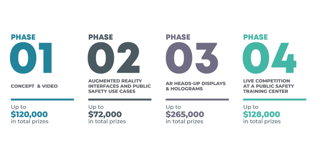
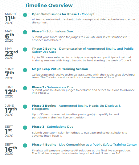
The Concept Paper and Video phase invites all eligible contestants to submit a concept paper and video outlining their team’s proposed solution, approach, capabilities, knowledge, and skills for this contest. Contestants must document their proposed augmented reality (AR) interfaces – holograms for incident command perspective and heads-up displays for first responders – for the four emergency scenarios. Contestants must either include a first responder as part of their team or sign a statement that they would be willing to collaborate with a partnered first responder agency to ensure applicability and alignment of their AR interfaces during the challenge. Contestants will also need to demonstrate their augmented reality proficiency through a three-minute (maximum) recorded video of either their AR portfolio or a sample AR interface created for this Challenge.
Contestants’ concept papers and recorded videos will be reviewed by a panel of subject matter experts; the judging panel will evaluate and select up to 30 contestants for awards. Awardees will receive: a) an invitation to Phase 2; Contestants will also be loaned a Magic Leap headset to be utilized during the competition and returned at the final event or during the contestants’ last participation in the Challenge.
Review the emergency scenarios and desired corresponding public safety tasks provided on the challenge website. By the May 6th deadline, submit a concept paper and link to a recorded video through the challenge website.
COVER PAGE & ABSTRACT (1 PAGE)
PROJECT DESCRIPTION (6 PAGES MAX)
Addressing the scoring criteria should be your primary objective; therefore, create your concept paper to address the criteria. Below are a few items to consider: The participant’s knowledge, skills, and capabilities as they relate to the goals of the challenge. The participant’s proposed augmented reality interfaces - holograms for incident command perspective and heads-up displays for first responders - for the four emergency scenarios; The competitive advantage offered by the participant’s approach or solution.
INFORMATION ABOUT KEY TEAM MEMBERS (2 PAGES)
Information describing the first responder point of contact, a description/details of the collaboration (including acknowledgement of prizes reserved for the collaborating public safety agency) with a public safety agency or entity. This information should be signed by the project’s point of contact at the collaborating public safety entity.
INFORMATION ABOUT PUBLIC SAFETY COLLABORATION (1 PAGE)
Information describing the first responder point of contact, a description/details of the collaboration (including acknowledgement of prizes reserved for the collaborating public safety agency) with a public safety agency or entity. This information should be signed by the project’s point of contact at the collaborating public safety entity.
CONCEPT SKETCH (1-2 PAGES)
A concept sketch of the interfaces and proposed solution in a PDF format.
MOCK UP VIDEO (1-3 MINS)
Submit a single video provided through an accessible online link within the application materials highlighting their concept, team skill set, and showcasing a virtual or augmented reality project.
Concept Paper and Mock Up Video submissions will be evaluated based on the following criteria:
70% STRATEGIC ALIGNMENT & TECHNICAL OUTCOMES
The extent to which the proposed approach meets the challenge objectives listed in the goals of the challenge.
The likelihood that the contestants(s) solutions, if successfully implemented will have a significant real-world impact on public safety operations.
Extent to which the proposed approach will result in significant improvement in commercially available technology and will potentially result in a technical outcome which enables considerable progress toward the challenge goals.
30% FEASIBILITY & TEAM
The extent to which the capability of the contestant(s) can address all aspects of the proposed project with a high chance of success, including, but not limited to, qualifications, relevant expertise, and time commitment of the contestant.
Phase 2 evaluation will be based on the following criteria:
Compliance Testing (Pass/Fail)
Phase 3 evaluation will be based on the following criteria:
Phase 4 evaluation will be based on the following criteria:
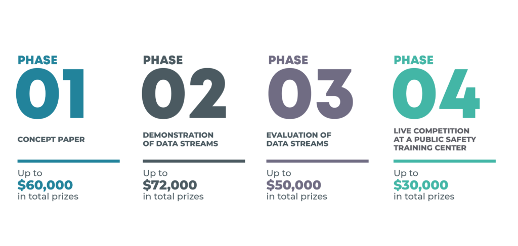
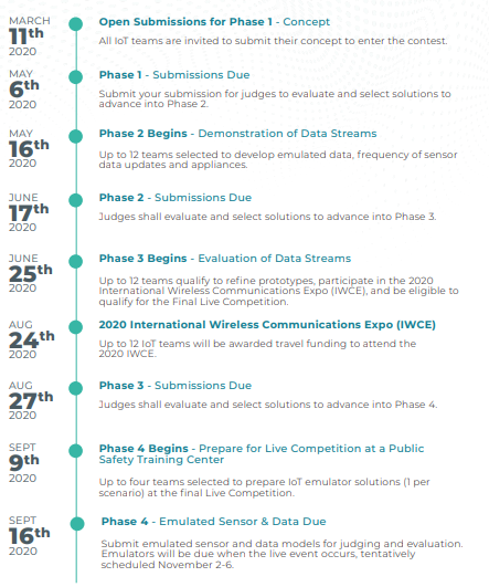
In the Concept Paper phase, all eligible participants are invited to submit a concept paper outlining their proposed team’s solution, approach, capabilities, knowledge, and skills. Participants must document their proposed solution structure for each of the four emergency scenarios, including the list of sensor data they would provide and a corresponding justification for their selection; their methodology for data acquisition and sources; and proposed physical hardware.
Participants will also need to demonstrate their experience with networking and socket programming and other abilities to create the hardware device that will transmit the emulated data in phases 3 and 4. Note: the network client must operate on an x86 platform, such as Raspberry PI, Windows, Linux or MacOS laptop computer. However, the proposed hardware for Phases 3 and 4 must operate on a system compatible with Raspberry Pi 4, Linux-based OS.
Participants’ concept papers will be reviewed by a panel of subject matter experts; the judging panel will evaluate and select up to 12 contestants to move forward to the next phase of the contest and to receive an award of $5,000 for prototype development.
Review the phases and Official Rules; review the emergency scenarios and desired corresponding public safety tasks provided on the challenge website. By the May 6th deadline, submit a concept paper through the challenge website.
COVER PAGE (1 PAGE)
PROJECT DESCRIPTION (6 PAGES MAX)
Create your concept paper to address the following criteria:
INFORMATION ABOUT KEY TEAM MEMBERS (2 PAGES)
The key team members and why they are well-suited to accomplish the project, with supporting information on their qualifications, skills and capabilities.
Concept Papers will be evaluated based on the following criteria:
70% STRATEGIC ALIGNMENT & TECHNICAL OUTCOMES
The extent to which the proposed approach meets the objectives listed in the goals of the challenge.
The likelihood that the contestant’s solution, if successfully implemented, will have a significant real-world impact on public safety operations.
Contestant’s concept paper properly outlines their proposed sensors and justification, their data acquisition methodology and their proposed hardware.
30% FEASIBILITY & TEAM
The extent to which the capability of the contestant(s) can address all aspects of the proposed project with a high chance of success, including, but not limited to, qualifications, relevant expertise, and time commitment of the contestant(s).
Phase 2 Evaluation will be based on a Compliance Test (Pass/Fail)
Phase 3 Evaluation Criteria will be based on the following criteria:
Phase 4 Evaluation Criteria will be based on the following criteria:
Primary First Responders: Law Enforcement
Scenario Narrative
At approximately 9:30 AM an employee notices a masked individual entering her office complex. The masked individual is carrying a large black bag and wearing a long trench coat. The employee thought this was odd and begins to walk away, grabbing her cell phone to notify the police.
Upon picking up her cell phone, the employee begins hearing gunfire. The masked shooter has entered the reception area and has opened fire on multiple employees.
The receptionist who was on the phone, was the first person killed. The masked shooter begins to look for more employees to shoot.
Thirty to forty people work in the office. Doors are being slammed shut, and the sounds of people yelling could be heard throughout the entire office space.
9:57 AM a 911 operator reported receives the following call:
At 10:15 AM, approximately ten police department patrol cars arrive on the scene. The dispatcher indicates all recent calls are reporting a shooting inside the Financial Center, on the third floor, but no additional details.
Two officers are positioned next to the main company elevator when the elevator doors open. People rush out the doors. Additional police officers enter the building and are heading to the elevators and emergency stairwells.
Incident Command Tasks
Hologram Use Case
First Responder Tasks
Heads Up Displays
Use Case
Primary First Responders: Emergency Medical Service, Fire Service, and Law Enforcement
Scenario Narrative
Misfortuneville, U.S.A. has a state-of-the-art emergency preparedness/response center, and the city itself has been outfitted with the newest sensors to keep its residents safe. None of that’s important right now. This morning, the National Weather Service reported strong storms in the area during the afternoon, and alerted residents to stay alert for flash flooding.
At 2:00 PM, the rain began at a rate of 3” per hour and was projected to move along within the hour. Being flood prone, the city is equipped with flood water level sensors in low lying areas. These sensors were activated at 2:30 PM and showed 4” of standing water already. This information was electronically distributed to emergency dispatch maps for use in communication.
At 3:00 PM, the National Weather Service indicated that although the storm had been originally indicated to exit the area in a short period of time, the storm had stalled, and rain could be expected to continue over Misfortuneville, U.S.A. for the next few hours. The original flood watch was upped to a flood warning.
At 3:30 PM, the city established its emergency flood response center in preparation for a prolonged rain event. The emergency flood response center personnel included the city emergency manager, public works manager, and dispatch personnel. Both the city officials and the dispatch personnel have access to a situational awareness platform showing the state of the city at the current time or a projected time in the future. This platform was also available to incident command and apparatus at localized incidents.
Incident Command Tasks
The emergency center’s main concern was resident safety, and to accomplish this, they prepared to execute the following tasks:
Hologram Use Cases
First Responder Tasks
The emergency center’s main concern was resident safety, and to accomplish this, they prepared to execute the following tasks:
Heads-up Display
Use Cases
Primary First Responders: Emergency Medical Service and Fire Service
Scenario Narrative
There is a train derailment with associated fire and smoke. Passengers call 911 and report the incident. Sensors on the tracks locate where the derailment occurred and nature of the cars (e.g., on/off tracks). CCTV security cameras inside tunnel show real-time footage of the smoke from the trains. Sensors on the cars indicate number of passengers in each car and status of the doors and emergency exits. Additional sensors in the tunnel share smoke levels, temperature, CO2, emergency lighting, and status of the rail (3rd Rail) that is electrified.
Additional sensors are available in the station including environmental sensors indicating smoke and CO2 entering. Firefighters respond to the area at the next station up and are able to load a fire suppression unit on the tracks to respond to the fire. Responders travel down the tracks and locate the front car of the train. Various communications occur throughout the event. Responders attack the fire and then proceed to open up the side doors and evacuate the passengers inside.
Due to heavy smoke, responders could not see the train in the tunnel until they were right next to it. Radio communication was sporadic in the subway stations and tunnels. The side door of the train required special keys and would not open for passengers. One person on the train was found unconscious. The following were dispatched:
Passengers and pedestrians near the subway station were evacuated. Rescue personnel estimate that the evacuation was completed by 16:25.
Incident Command Tasks
Hologram Use Case
First Responder Tasks
Heads Up Display
Use Case
Primary First Responders: Fire Service and Emergency Medical Service
Scenario Narrative
Last Friday, a wildfire started in the mountains above Misfortuneville, U.S.A. Firefighters suspect the fire originated at a camp site located off of I-70.
Today at 8:00 AM, although the fire continues to burn in remote areas, firefighters have made significant progress in recent days, containing approximately 75-80% of the fire aided by unexpected rain showers and calmer winds. Evacuation orders have been lifted for Misfortuneville, U.S.A., but hundreds of people remain in shelters, awaiting permission to return to their homes. Local law enforcement has restricted access to heavily damaged areas and established a curfew in some portions of the community to prevent looting. Power remains out in several major residential areas.
Firefighters are tasked with assessing assets still at risk, identifying the burn areas, and containing the rest of the fire before it has a chance to spread to other cities and towns. An air tanker is seeking information to drop water and fire retardant onto areas of the wildfire. The job of the firefighters is to eliminate three areas where the fire is at its most intense levels to prevent further damage.
Incident Command Tasks
Hologram Use Case
First Responder Tasks
Heads Up Displays Use Case