menu

Submission

submission voting
voting is closed.
introduction
title
Two-way encrypted mapping and messaging system
short description
Enables the transmission of detailed, annotated maps (i.e. weather, enemies, and objectives) without the overhead of large data file sizes.
Bio
Introduce yourself or your team
We are a father-son team. Brent McCallister is the father and Jason McCallister is the son.
What makes you an ideal candidate for this Challenge?
Jason has way too many hobbies. Some of these hobbies include electronics, programming, robotics, woodworking, and amateur astronomy. Jason participated in the NASA Space Robotics Centennial Challenge (2016-2017) whose goal was to develop and display abilities of the R5 robot. He was a solo team that competed with 405 other teams. After making it as far as the final 42 teams with valid submissions, he missed the top 20 finalists by 1.894 seconds (estimated). He also has developed many electronics projects utilizing Arduino, Raspberry Pi, RFID, magnetometer, accelerometer, gyroscopes, and I2C.

Brent also has way too many hobbies and contributed to Jason’s hobbies by supplying him with electronics kits and computers starting with a Timex Sinclair in 1982. Brent is a Landscape architect, photographer, amateur astronomer, artist, woodworker, and science enthusiast. Brent combined astronomy and photography starting in the mid 80’s with an 8-inch Newtonian reflecting telescope. And of course, being in Florida, both Brent and Jason have made numerous trips to Cape Canaveral on NASA’s various launch days.
Solution
Describe your solution.
Annotated Map Overlays.

Transmit only annotated map overlays rather than entire maps. This enables the transmission of detailed, annotated maps (i.e. landmarks, weather, enemies, and objectives) without the overhead of large data file sizes.
• Example annotated map overlay of Afghanistan = 28 KB
• Example detailed satellite image maps of Afghanistan = 738 TB
• The annotation is over 28,000,000,000 times SMALLER than the full map.

A typical CubeSat can only transfer 1.8 MB of data per day (combined uplink and downlink).

Highly detailed satellite images are approximately 3 GB per square mile. That would take over FOUR YEARS to transmit one square mile!

The small overlay size would allow the transmission of up to 66 different regional annotations in a single day.

*See attachment for details on numeric derivations.

This method of creating map overlay files uses GIF or PNG image formats with transparency.

Steps for communication between Special Forces and Command Control:
1. Special Operations Forces will be deployed with military-grade, rugged notebook computers. These computers are preloaded with detailed satellite image maps of the region in which they will be operating
2. Command Control will:
a. Annotate maps with required information
b. Upload annotations and messages to CubeSat (To: Special Forces)
c. Download annotations and messages from CubeSat (From: Special Forces)
3. Special Forces will:
a. Annotate maps with required information
b. Upload annotations and messages to CubeSat (To: Command Control)
c. Download annotations and messages from CubeSat (From: Command Control)
4. Repeat steps 2 and 3

Working code created with open-source software is attached. Software / User Interface (UI) will be built to:
• Create annotations
• Separate annotations from map using ImageMagick command
• Upload/Download annotations and messages to CubeSat (Raspberry Pi)
• Re-combine annotations with maps using HTML and CSS
What is the size of your proposed solution?
VOLUME:

This solution will easily fit in CubeSat space less than 1.5U.

The payload hardware consists of:
• Raspberry Pi 3 Model B: 86.9mm (L) x 58.5mm (W) x 19.1mm (H)
• Micro SD Card (128 GB) – Adds an additional 3 mm in length to the Raspberry Pi

TOTAL VOLUME: 89.9mm (L) x 58.5mm (W) x 19.1mm (H)

WEIGHT:

Raspberry Pi weight: 41.2 g
Micro SD weight: 0.5 g

TOTAL WEIGHT: 41.7 g
Does your solution help Special Operations Forces missions? How?
Goal:
Reconnaissance and intelligence gathering are important roles for Special Operation Forces.
Timely and accurate Geographic Information System (GIS) data is key to the success of USSOCOM and Special Forces activities.

Data from Command Control to Special Forces
• Weather data – is important in determining whether to take shelter or head to high ground due to heavy rain, temperature swings, dust storms, etc.. GIS data can highlight dangerous areas prone to river flooding, landslides, etc.
• Establishing cover – is facilitated with GIS data showing terrain, vantage points, and target locations
• Rendezvous points – can be communicated with GIS data for extractions, force combination, and mission objectives.
• Enemy locations – can be communicated via GIS data to show location, size, and type of enemy forces.
• Landmarks – can be communicated via GIS to help with visual navigation.

Data from Special Forces to Command Control
• Enemy locations – can be communicated via GIS data to show location, size, and type of enemy forces.
• Surveillance of target – such as force movements, activities, man-hunting, and hostage tracking.
• Encrypted and fast – Transmit information back to command quickly and securely.

Problem:
• Special Forces need up-to-date maps with enemy locations, mission objectives, rendezvous points, and weather conditions.
• Oftentimes Special Forces are deployed to areas out of range of traditional communications.
• Satellite phones are not secure and text messages are limited to 160 characters.
• Detailed maps use a lot of storage space. Transmitting maps would also use a lot of bandwidth.
• CubeSats have limited bandwidth and are typically only available 3-16 times a day for up to ten minutes.
• Transmitting a detailed map of one square mile would take over FOUR years!
Where known, identify platform accommodation requirements for power.
The Raspberry Pi 3 Model B voltage requirement is: 5 V

The Raspberry Pi 3 Model B base power consumption is: 400 mA

The peak Raspberry Pi 3 Model B power consumption when sending mapping overlay data to satellite transceiver via USB is: 1.6 Amps (1.2 Amps USB + 400 mA base)

https://www.raspberrypi.org/help/faqs/#powerReqs
Where known, identify platform accommodation requirements for thermal control.
Recommended payload operating temperature should be between -20 C to +60 C.

This is based on the innermost range of the components listed below.

Raspberry Pi has been reported to operate between -100 C to + 85 C.
https://www.geek.com/chips/raspberry-pi-proven-to-be-stable-when-submerged-in-liquid-nitrogen-1555235/
https://raspberrypi.stackexchange.com/questions/103/whats-the-maximum-minimum-running-temperature

Commercial SD cards are specified to operate between -20 C to +65 C.
http://www.cubesatkit.com/content/faq.html

Electronics in general should operate between -20 C and 60 C
http://cubesat.ece.illinois.edu/Structure.html
Where known, identify platform accommodation requirements for data transfer rate.
Data transfer rate is based on a standard CubeSat rate of 1.8 MB per day as determined in “DIY Comms and Control for Amateur Space” by Sandy Antunes. This includes both uplink and downlink communications.

Assumptions:
• 9600 bits per second transceiver speed
• 5 minutes per contact
• 5 orbits per day with contact
• 10 orbits per day without contact

This is a good average depending on the geographic location and the type of orbit.
Where known, identify platform accommodation requirements for data transfer volume (per orbit).
The Raspberry Pi 3 Model B will use a Micro SD Card (128 GB).

Approximately 8 GB of this will be used by OS and Map Overlay library management.

The remaining 120 GB is enough to store over 4 million map overlay files at 28 KB.

Information that has already been download can be deleted after each orbit.
Where known, identify platform accommodation requirements for bus stability and attitude control.
No bus stability or attitude control is necessary. Assuming there are four dipole antennas mounted perpendicular to each other in a cross shape (see next section).
Can you identify any additional platform accommodation requirements for your solution?
Four dipole antennas mounted perpendicular to each other in a cross shape.

This will ensure that no matter how the satellite is oriented relative to the ground, a signal can still be received or transmitted.

Assuming the transceiver frequency is between 430 and 450 MHz, one-half wavelength antennas about 35 cm will be sufficient.

Assuming the core CubeSat includes a transceiver set up to use:
• Encryption
• CCSDS Space Packet Protocol
• CCSDS File Delivery Protocol

Assuming the Special Forces have a handheld transceiver and Military-grade notebook set up to use:
• Encryption
• CCSDS Space Packet Protocol
• CCSDS File Delivery Protocol
• Collapsible Yagi Antenna to maximize signal strength

Assuming the Command Control is set up to use:
• Encryption
• CCSDS Space Packet Protocol
• CCSDS File Delivery Protocol
Can your concept can be implemented with current state-of-the-art flight-qualified components, or will it require additional development? Please describe.
All required software is open source.

No specialized GIS software needs to be created.

This can be accomplished using existing technology.

Software:
• GIF or PNG Images
• ImageMagick
• HTML and CSS
• Any image editor such as Paint, GIMP, Photoshop, etc..

Hardware:
• Raspberry Pi 3 Model B (satellite)
• Micro SD card 128 GB (satellite)
• Military-grade, rugged notebook (ground station)
• Handheld transceiver (ground station)
• Collapsible Yagi antenna (ground station)

Software Setup:
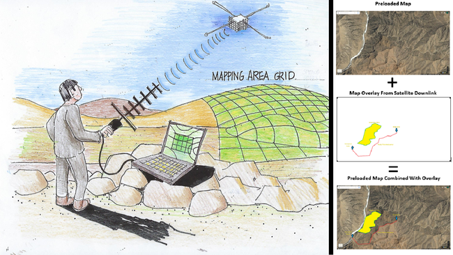
• This can be accomplished using GIF or PNG image files with transparency.
• Existing open-source software called ImageMagick can easily separate the annotations from the map. In fact, I have already included working code in the attachment.
• CSS and HTML language which is already included with every browser can join the annotations with the maps. I have also included working code for this in the attachment.
• Development of complex GIS software is unnecessary.
• Onboard Satellite Prioritization algorithm will determine what to upload or download based on priority and limited time.

Hardware Suitability:

Typical Low Earth Orbit (LEO) Satellites can be expected to receive a Total Ionizing Dose (TID) of 1.2 krad(Si).
https://pdfs.semanticscholar.org/6cbd/40e77f381775a37e6dbed10edc5e13ace1a0.pdf

Raspberry Pi Model B boards have been tested to handle up to 40 krad(Si).
https://nepp.nasa.gov/workshops/eeesmallmissions/talks/11%20-%20THUR/1430%20-%202014-561-%20Violette-Final-Pres-EEE-TN17486%20v2.pdf

MicroSD memory cards have been tested to handle up to 8 krad(Si).
https://pdfs.semanticscholar.org/6cbd/40e77f381775a37e6dbed10edc5e13ace1a0.pdf
Intellectual Property: Do you acknowledge that this is only the Concept Phase of the competition, and all ideas are to remain the property and ownership of USSOCOM for future discretionary use, licensing, or inclusion in future challenges?
Yes
Supporting PDF upload
CubeSatMappingEntry.pdf

comments (public)