The FishAngler app is FREE Sports fishing app that is currently in the IOS and Android stores. The app is designed to capture, track, and share your fishing stories and photos while keeping your finest fishing experiences at your fingertips. Anglers can connect & share stories and photos with other anglers, log detail catches details & fishing reports and discover new fishing spots.
Currently the app uses the following government & open data sets:
• The
FishBase.org database for fish information & identification
• The USA National Hydrography Dataset (NHD)
o Maps 8.5 Million Bodies of water in USA
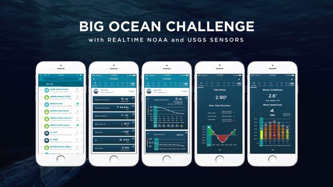
With this new feature we are providing FREE real time access to NOAA & USGS water sensors including weather, wind conditions, tide predication, wave conditions, water temperatures, water levels & flow rates as well as various sun and moon information based on user’s location.
Also when a user posts a fish species catch within the app will have this weather, water data, tide info, moon phases, sunrise data automatically tagged to the fish catch posting. The will allow us to do trending long term on environmental conditions at the time of the catch.
We are using the following data sets or API’s:
• NOAA - (IOOS) Sensor Observational Service (SOS)
• NOAA - National Water Level Observation Network (NWLON) stations
• USGS - National Water Information System (NWIS)
o USGS Water Levels in Rivers & Streams
• NOAA - National Data Buoy Center Stations
• NOAA - Tidal & Current predication
• Naval Observatory Vector Astrometry Software - C Edition C3.1
Categories we are competing in:
Fishing
• We are expanding the user fishing experience by allowing users to see real-time monitoring stations providing a forecast for the following:
NOAA Weather (wind, wave, water temp, currents, weather forecasts)
NOAA Tidal predication
Sun & Moon forecast
USGS Water levels in rivers & streams
• Also, this data will allow us to tag all fishing catch posts with wind conditions, tide predication, wave conditions, water temperatures, water levels & flow rates as well as various sun and moon information based on user’s location.
Public Safety
o We are providing a way for a user to report safety issues observed while on the water which will be broadcasted to our user base.
o Submerged Objects
o Floating Objects
o Waves
o Red Tide
o Jelly fish
o Algal blooms
Exploration
• Species Identification
o We will be using public domain NOAA photos to expanded fish identification photo library and will provide fish species information on 33,000 fish species.
• Species discovery
o As fish species photos are posted with GPS tags fish species distribution can we tracked within app
Innovation:
The NOAA and USGS weather, water and tidal data for the first time will be pulled into a sports fishing app free of charge for end users. Our hope is to create a fishing community of millions of anglers sharing rich catch data for both the scientific community and the fishing industry.
Impact:
Our hope is that by allowing the fishing community better access to NOAA and USGS weather & water datasets in an easy to use format we can open up this data to millions of users.
Today there are 45 million anglers in the USA and approximately 250 million anglers worldwide. By enabling the crowd source collection of fish catch data tagged with rich environmental data will greatly help Fisheries managers.
Fisheries managers can go out and collect all of the data they want from state and federally regulated commercial fisherman, but that does not provide a full picture for a fishery. This big picture remains unfinished due to the difficulty of getting recreational angler data. Recreational anglers are not required to report their catches or their catch effort- which is important to know when putting together a management program. Recreational anglers aren’t too keen on talking to agency officials about where, how and what they’ve been fishing for either. Data is collected from recreational anglers, but not close to the actual amount of fishing pressure that they exert on the fishery and fisheries managers have longed for a more precise, accurate way to account for recreational anglers and their impact on the fishery. This will also ensure for a more well- managed fishery.